An introduction to GHRSST specified/formatted products
We refer to GHRSST as “formatted” or “specified” products (and not GHRSST products) because there is a wide range of SST data producers worldwide that use the GHRSST format and specifications to provide SST products in prescribed formats. GHRSST itself does not provide any products.
- What does GHRSST offer?
- Which data sets should I use?
- How to select a satellite SST product?
- What is SST?
- Which tools are available for quick looks/visualization of SST products?
- Which tools are available for the validation of SST products in near real-time?
- Is there a catalogue for GHRSST-specified products? Where can I find it?
- Q&A collection of questions asked by GHRSST users
See the resources listed below.
What does GHRSST offer?
GHRSST data producers (DACs) can supply Sea Surface Temperature (SST) data in satellite swath coordinates (L2P), gridded data (L3), and gap-free gridded products (L4).
- L2P data products provide satellite SST observations together with a measure of uncertainty for each observation in a common GHRSST netCDF format. Auxiliary fields are also provided for each pixel as dynamic flags to filter and help interpret the SST data. These data are ideal for data assimilation systems or as input to analysis systems.
- Gridding a single L2P file produces an “uncollated” L3 file (L3U). Multiple L2P files are gridded to produce either a “collated” L3 file (L3C) from a single sensor or a “super-collated” L3 file from multiple sensors (L3S).
- L4 gridded products are generated by combining complementary satellite and in situ observations within Optimal Interpolation systems. L4 gridded products are provided in GHRSST netCDF format. These data are ideal for model diagnostic studies, model boundary condition specification and model initialisation.
GHRSST itself does not provide any data, but you can download data from the respective RDACs, or as collected by the GHRSST Global Data Archiving Centre (GDAC) at NASA JPL.
Please note that the GHRSST Project Office does not produce or distribute data directly, so you best write to the data producers of the dataset you are using. This can be easily found if you look at the global attributes of one nc file, typically called “creator name” or “creator email”.
The GHRSST Quick introduction to the set of GHRSST formatted products is a quick guideline for SST users on the use of GHRSST formatted products. You can download it from Zenodo: https://doi.org/10.5281/zenodo.7589540
Cite as: GHRSST Project Office, Beggs, Helen, Karagali, Ioanna, & Castro, Sandra. (2023). Sea surface temperature: An introduction to users on the set of GHRSST formatted products (1/2023). Zenodo. https://doi.org/10.5281/zenodo.7589540
Which data set should I use?
Before deciding on the data set users should be aware of the definitions of skin, sub-skin, and foundation temperatures, which are summarised below, as well as other aspects that might influence your choice by the requirements of your application, such as sampling intervals and the length of the data sets:
- Infra-red instruments measure SST skin at high spatial resolution but the surface is obscured by clouds.
- Microwave instruments measure an approximation to the SST subskin, including through clouds and thus have fuller cover-age but at a reduced spatial resolution and beyond 50-100 km from land.
- Geostationary satellites carry only infrared imagers, and have high temporal resolution and fixed spatial coverage centred on the Equator.
- Polar orbiting satellites have higher spatial resolution.
Products blended from multiple satellites or multiple passes of the same satellite (L3S, L4) use different methods to combine the observations from several sensors and to preserve the resolution or gradients in SST.
How to select a satellite SST product?
To select from an increasingly wide array of SST products, you need to consider which of the following parameters are most important for the application and analyses being undertaken (Beggs, 2021):
| · SST measuring depth- skin, subskin, or foundation?
· Temporal needs -are the dataset extent, local time of measurement, and latency suitable? Or is the local time of measurement (night, noon) an issue? · Temporal resolution—what is the characteristic time period of the process you wish to measure? Daily or sub-daily? · Spatial resolution – how fine a resolution is required for the feature/ process of interest? · Spatial coverage completeness – gaps versus gap-free? · Do you need microwave data to measure SST under cloud, for example during or after a tropical cyclone? · Quality level (cloud/rain contamination) – what is the minimum acceptable level? · Level of processing – native projection (L2P) or gridded (L3 or L4) or analysed (L4)? · SST accuracy and stability- with respect to what reference? Is it for climate applications? · Stability of sensor and orbit – what deviation is acceptable? |
What is SST?
SST is a challenging parameter to define precisely as the upper ocean (~10 m) has a complex and variable vertical temperature structure that is related to ocean turbulence and air-sea fluxes of heat, moisture and momentum. A theoretical framework is therefore required to understand the information content and relationships between measurements of SST made by different satellites and in situ instruments, especially if these are to be merged together. The definitions of SST developed by the GHRSST SST Science Team (agreed at the 2nd and 3rd workshops) achieve the closest possible coincidence between what is defined and what can be measured, taking into account current scientific knowledge and understanding of the near-surface thermal structure of the ocean.
The definitions of SST defined by GHRSST are currently being refined by the Science Team. Once approved, the GHRSST SST definitions will be iterated with the Climate and Forecast (CF) metadata convention definitions of SST to ensure they are in agreement.
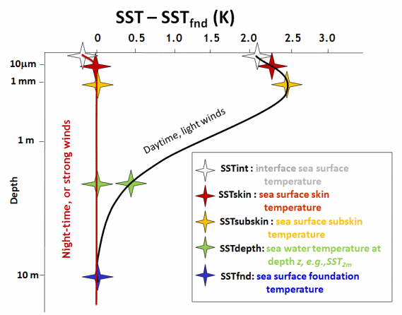
The figure below presents a schematic diagram that summarises the definition of SST in the upper 10 m of the ocean and provides a framework to understand the differences between complementary SST measurements. It encapsulates the effects of dominant heat transport processes and time scales of variability associated with distinct vertical and volume regimes of the upper ocean water column (horizontal and temporal variability is implicitly assumed).
SST Definitions
Each of the definitions marked in the bottom right of the figure is explained below and in this discussion document.
The interface temperature (SSTint)
At the exact air-sea interface a hypothetical temperature called the interface temperature (SSTint) is defined although this is of no practical use because it cannot be measured using current technology.
The skin sea surface temperature (SSTskin)
The skin temperature (SSTskin) is defined as the temperature measured by an infrared radiometer typically operating at wavelengths 3.7-12 µm (chosen for consistency with the majority of infrared satellite measurements) that represents the temperature within the conductive diffusion-dominated sub-layer at a depth of ~10-20 µm. SSTskin measurements are subject to a large potential diurnal cycle including cool skin layer effects (especially at night under clear skies and low wind speed conditions) and warm layer effects in the daytime.
The sub-skin sea surface temperature (SSTsub-skin)
The subskin temperature (SSTsubskin) represents the temperature at the base of the conductive laminar sub-layer of the ocean surface. For practical purposes, SSTsubskin can be well approximated to the measurement of surface temperature by a microwave radiometer operating in the 6-11 GHz frequency range, but the relationship is neither direct nor invariant to changing physical conditions or to the specific geometry of the microwave measurements.
The surface temperature at depth (SSTz or SSTdepth)
All measurements of water temperature beneath the SSTsubskin are referred to as depth temperatures (SSTdepth) measured using a wide variety of platforms and sensors such as drifting buoys, vertical profiling floats, or deep thermistor chains at depths ranging from 10-2 – 103m. These temperature observations are distinct from those obtained using remote sensing techniques (SSTskin and SSTsubskin) and must be qualified by a measurement depth in meters (e.g., or SST(z) e.g. SST5m).
The foundation temperature (SSTfnd)
The foundation SST, SSTfnd, is the temperature free of diurnal temperature variability, i.e., SSTfnd is defined as the temperature at the first time of the day when the heat gain from the solar radiation absorption exceeds the heat loss at the sea surface. For conditions, when the SST increases or decreases monotonically over several days, the Tfnd occurs on a given day when the time rate of change of temperature is at a minimum (increasing SST), or a maximum (decreasing SST). If such a point in the daily time series cannot be identified, the SSTfnd should be set to a clearly stated time. SSTfnd is named to indicate that it is the foundation temperature upon which the growth and decay of the diurnal heating develop each day. Only in situ contact thermometry is able to measure SSTfnd and analysis.
Which tools are available for quick looks/visualization of SST products?
- A particularly useful web tool for quick looks at a range of GHRSST L2P, L3U, L3S and L4 SST products over defined ocean regions is the NOAA/NESDIS/STAR ACSPO Regional Monitor for SST website 1 (ARMS): https://www.star.nesdis.noaa.gov/socd/sst/arms/
- CEOS COVERAGE website https://coverage.ceos.org/ displays GMPE and JPL MUR 25km SST data along with a wide range of other satellite and in-situ ocean data.
- NOAA/NESDIS/STAR OceanView web tool displays NOAA GeoPolar Blend L4 SST and fronts https://www.star.nesdis.noaa.gov/socd/ov/ along with other satellite and in-situ ocean data.
- The Copernicus Marine Service displays and distributes a suite of L4 and L3S GHRSST products for the European Seas and also the global ocean https://marine.copernicus.eu, along with other ocean parameters.
- A web-based visualization tool with many products and ocean variables is the Ocean Data Laboratory https://ovl.oceandatalab.com/.
- A list of available L4 GHRSST SST products for visualization over the last 7 days and monitoring is available through the GMPE tool https://ghrsst-pp.metoffice.gov.uk/ostia-website/gmpe-monitoring.html GMPE is the ensemble median of all the GHRSST products.
- NOAA SQUAM: L4 NRT, Global Quality Monitoring system https://www.star.nesdis.noaa.gov/socd/sst/squam/ and its counterpart for in situ data, iQUAM https://www.star.nesdis.noaa.gov/socd/sst/iquam/
- Only applicable over Australia and surrounding countries, the IMOS Ocean Current website is really useful for a quick look at SST, ocean current and ocean colour conditions http://oceancurrent.imos.org.au/
Which tools are available for the validation of SST products in near real time?
- EUMETSAT L2P: http://metis.eumetsat.int/sst
- JAXA AMSR-2 L2P: https://suzaku.eorc.jaxa.jp/cgi-bin/gcomw/validation/gcomw_validation_ssti1.cgi
- GMPE validation tool: GMPE is the ensemble median of all the GHRSST products https://ghrsst-pp.metoffice.gov.uk/ostia-website/gmpe-monitoring.html
- NOAA/NESDIS SQUAM L2P/L3U/L4: SST Quality Monitor 2.1: http://www.star.nesdis.noaa.gov/sod/sst/squam
- NOAA/NESDIS iQUAM: in situ SST Quality Monitor v2.10: https://www.star.nesdis.noaa.gov/socd/sst/iquam/
- UK Met Office L4 validation: https://ghrsst-pp.metoffice.gov.uk/ostia-website/gmpe-argo-stats.html
Is there a catalogue for GHRSST-specified products? Where can I find it?
The catalogue will be available soon via the GHRSST website on this page.
An introduction to how the system will work is provided in this video
A manual for SST data users is also in preparation.
Reference documents
Beggs, H. (2021). Temperature. Ch. 14 in Earth Observation: Data, Processing and Applications. Volume 3B—Surface Waters. CRCSI, Melbourne. pp. 245–279. ISBN 978-0-6482278-5-4.
Beggs, H. (2010). Use of TIR from Space in Operational Systems, In: Oceanography from Space Revisited. (Eds: V. Barale, J.F.R. Gower and L. Alberotanza). Springer Science+Business Media B.V. pp. 249–271. doi:10.1007/978-90-481-8681-5. https://www.researchgate.net/publication/259823623_Use_of_TIR_from_Space_in_Operational_Systems
Beggs et al. (2018) Beggs, H., Griffin, C., Govekar, P., Majewski, L., Qi, L., and Zhong, A. (2018b). Which IMOS GHRSST product should I use? Presented at the IMOS Data Workshop, Adelaide, Australia, 6 July 2018. http://imos.org.au/fileadmin/user_upload/shared/SRS/SST/IMOS_Data_Workshop-SST-Beggs_08Jul2018.pdf
Dash, P., Ignatov, A., Martin, M., Donlon, C., Brasnett, B., Reynolds, R., Banzon, V., Beggs, H., May, D., McKenzie, B., Cayula, J-F., Chao, Y., Grumbine, R., Maturi, E., Harris, A., Mittaz, J., Sapper, J., Chin, T., Vazquez, J., Armstrong, E., Gentemann, C., Cummings, J., Piolle, J-F., Autret, E., Roberts-Jones, J., Ishizaki, S., Hoyer, J., and Poulter, D. (2012). Group for High Resolution SST (GHRSST) Analysis Fields Inter-Comparisons Part 2. Near real-time web-based Level 4 SST Quality Monitor (L4-SQUAM). Deep Sea Research II, 77–80, 31–43.
Donlon, C., Casey, K., Robinson, I., Gentemann, C., Reynolds, R., Barton, I., Arino, O., Stark, J., Rayner, N., Le Borgne, P., Poulter, D., Vazquez-Cuervo, J., Armstrong, E., Beggs, H., Llewellyn-Jones, D., Minnett, P., Merchant, C., and Evans, R. (2009). The GODAE High-Resolution Sea Surface Temperature Pilot Project. Oceanography, 22, 34–45.
Fiedler, E.K., McLaren, A., Banzon, V., Brasmett, B., Ishizaki, S., Kennedy, J., Rayner, N., Roberts-Jones, J., Corlett, G., Merchant, C.J., and Donlon, C. (2019). Intercomparison of long-term sea surface temperature analyses using the GHRSST Multi- Product Ensemble (GMPE) system. Remote Sensing of Environment, 222
Merchant, C.J., Minnett, P.J., Beggs, H., Corlett, G., Gentemann, C., Harris, A.R., Hoyer, J., and Maturi, E.. (2019a). Global Sea Surface Temperature, In: Taking the Temperature of the Earth. Steps towards integrated understanding of variability and change (Eds: Glynn Hulley and Darren Ghent). P. 5–55. Elsevier. https://doi.org/10.1016/B978-0-12-814458-9.00002-2
O’Carroll, A.G., Armstrong, E.M., Beggs, H., Bouali, M., Casey, K.S., Corlett, G.K., Dash, P., Donlon, C.J., Gentemann, C.L., Hoyer, J.L., Ignatov, A., Kabobah, K., Kachi, M., Kurihara, Y., Karagali, I., Maturi, E., Merchant, C.J., Minnett, P., Pennybacker, M. Ramakrishnan, B., Ramsankaran, R., Santoleri, R., Sunder, S., Saux Picart, S., Vazquez-Cuervo, J., and Wimmer, W. (2019). Observational needs of sea surface temperature. Frontiers in Marine Science, 6, 420. https://doi.org/10.3389/fmars.2019.00420
The Group for High Resolution Sea Surface Temperature Science Team, Piollé, Jean-François, Armstrong, Ed, Casey, Kenneth, & Donlon, Craig. (2022). The Recommended GHRSST Data Specification (GDS) (GDS 2.1 revision 0). Zenodo. https://doi.org/10.5281/zenodo.6984989 https://zenodo.org/record/6984989#.Y9je5XaZNnI
Rayner, N., Good, S., Block, T., P. Evadzi, P., and Embury, O. (2019). SST-CCI-Phase-II SST CCI Product User Guide Issue 2, European Space Agency, 115 p. https://climate.esa.int/media/documents/SST_cci_PUG_v2.pdf
Yang, C., Leonelli, F.E., Marullo, S., Artale, V., Beggs, H., Nardelli, B.B., Chin, T.M., De Toma, V., Good, S., Huang, B., Merchant, C.J., Sakurai, T., Santoleri, R., Vazquez-Cuervo, J., Zhang, H.-M., and Pisano, A. (2021). Sea Surface Temperature intercomparison in the framework of the Copernicus Climate Change Service (C3S). Journal of Climate, 33(13), 5257–5283. https://doi.org/10.1175/JCLI-D-20-0793.1